Voorlopig kan met dit het grondgebied van de
Palestijnse autoriteit* noemen, of de "voorlopige Palestijnse staat":
De stukjes in rood (
*A + B) van de Westbank + Gaza strook:
(of zoals in de
*tekst van de bron onderaan*)
Citaat:

De A-gebieden en B-gebieden van de Palestijnse Autoriteit

Internationale erkenning van de Palestijnse Autoriteit
██ Erkenning van de Staat Palestina
██ Algemene diplomatieke betrekkingen
██ Speciale diplomatieke betrekkingen
██ Geen erkenning
http://nl.wikipedia.org/wiki/Palestijnse_Autoriteit
|
Begrijpt iemand die wereldkaart niet ?
Voor de rest is het wachten op "die bleiters"
:
bron: UN OCHA (VN)
http://kivafellows.wordpress.com/201...k-agriculture/
...]
The West Bank is divided into three areas: A, B, and C.
Area C, which constitutes 64% of the area, is under the military and civil jurisdiction of Israel.
*Area A is under the military and civil jurisdiction of the Palestinian Authority and contains most of the major urban areas in the Territory. Area B is the designation for most Palestinian villages and surrounding rural land; civil jurisdiction is under the Palestinian Authority* and military jurisdiction is shared with Israel. (Source: UN OCHA)
The UN Office for the Coordination of Humanitarian Affairs (OCHA) regularly releases reports and maps on the political geography of the West Bank:

Political map of the West Bank. Click for an enlarged version. (Source: UN OCHA)
Area C is in blue. It is the only contiguous Area of the West Bank, and, as such, necessarily contains land that is vital for linking Palestinian cities and for infrastructure development and water distribution. The dark blue regions on the map (70% of Area C) are closed completely to Palestinian construction. They include Israeli settlement areas and their surrounding rural zones, Israeli military zones, and Israeli designated nature reserves. The light blue regions are the remainder of Area C – still, only 1% of Area C is zoned by the Israeli Civil Authority for Palestinian development. (Source: UN OCHA)
The three West Bank Areas were demarcated in a 1995 Interim Agreement between Israel and the Palestinian Liberation Organization. The Agreement was meant to be a temporary step towards the final resolution of the Oslo Accords, and the partition was to last only until a final status agreement was reached by the year 2000.
Planning and zoning responsibilities in Area C were to be transferred to the Palestinian Authority in 1998, but they remain with Israel until today. (Source: UN OCHA)
~ herhaling van:
http://forum.politics.be/showpost.ph...&postcount=146
of-ook:
Citaat:
http://en.wikipedia.org/wiki/Palesti...2.80.93present
On Thursday, 29 November 2012, In a 138-9 vote (with 41 abstaining) United Nations General Assembly resolution 67/19 passed, upgrading Palestine to "non-member observer state" status in the United Nations.[6][11] The new status equates Palestine's with that of the Holy See. The change in status was described by The Independent as "de facto recognition of the sovereign state of Palestine".[50]
The vote was a historic benchmark for the partially recognised State of Palestine and its citizens, whilst it was a diplomatic setback for Israel and the United States. Status as an observer state in the UN will allow the State of Palestine to join treaties and specialised UN agencies, such as the International Civil Aviation Organisation,[51] the Law of the Seas Treaty and the International Criminal Court. It shall permit Palestine to claim legal rights over its territorial waters and air space as a sovereign state recognised by the UN, and allow the Palestinian people the right to sue for control of their territory in the International Court of Justice and to bring war-crimes charges against Israel in the International Criminal Court.[52]
The UN has permitted Palestine to title its representative office to the UN as 'The Permanent Observer Mission of the State of Palestine to the United Nations',[10] and Palestine has started to re-title its name accordingly on postal stamps, official documents and passports,[6][53] whilst it has instructed its diplomats to officially represent 'The State of Palestine', as opposed to the 'Palestine National Authority'.[6] Additionally, on 17 December 2012, UN Chief of Protocol Yeocheol Yoon decided that "the designation of 'State of Palestine' shall be used by the Secretariat in all official United Nations documents".[9]
Map showing governorates and areas of formal Palestinian control (Areas A and B in deep green):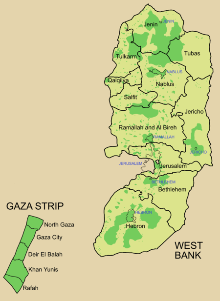
|